|
| July
2004: Jo and I decide to take a week off and go flying in EV. Our goal for
2004 was to fly to Jersey leaving the coast at the Isle of White, rather
than crossing at Dover - and maybe France also. So we booked a week off
in July with a plan to visit Jersey and France.
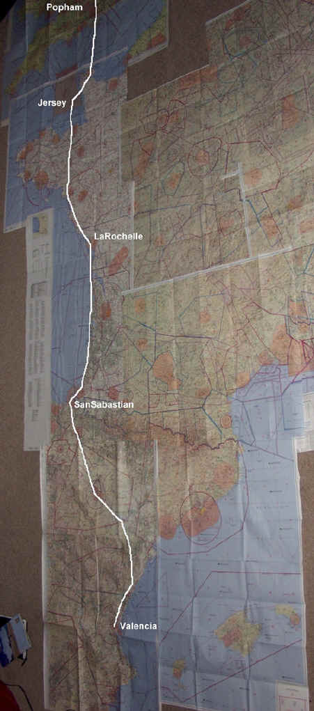
Our trip plan started as Jersey for two days, then La Rochelle for a few days with the possibility of Biarritz. However less than a week before we leave Jo asks if its possible to get to Spain - her parents live in Spain and its their wedding anniversary and Mere's birthday. I already had the maps as I had hoped to fly to Spain with a friend in his RV, so out they came and I started planning. The route/plan: I don't like running EV beyond 2.5 hrs (engine hobbs) so I planned the route to keep the legs within 2.5hrs. This was challenging as there are so few airfields in Spain and also, San Sabastian, La Rochelle, Biarittz and Jersey - that's most of my destinations - are prone to sea fog! I decided we would leave Popham as soon as possible on Saturday, to Jersey via Deauville. The next destination is La Rochelle, then onto San Sabastian for the night. On Sunday, depart San Sabastian to Zaragosa, then on to Valencia.
Saturday 24th July. We're up and looking out of the window - Popham is 12 miles away - the weather is great! Clear blue sky not too windy and cool, just what the weather report said. We're already well prepared and it's not long before Jo and I are heading out of the house and are on our way. But as we get close to the airfield mist starts to build and we arrive to a heavy morning mist, not daunted - knowing I also need fuel - we take the covers off Evy and refuel. The sun is burning through but I decide its not the way I want to start our trip so I phone Heathrow to move our flight plan back by 50 mins. This works nicely as the Sun soon burns through. We don life jackets and take-off from Popham on 26 at 9.50 climbing to 1500ft heading south for Portsmouth/Gosport. Once clear of Solent I climb to 2500ft, as we reach the south coast I call London Information and climb to 4000ft ready for the crossing as I pass over the IOW. The visibility is great, no cloud and it's a calm day as we head out from the IOW - I have checked D036 and we cross direct to Cherbourg. This is the first time I have made such a big water crossing and I am blessed with good weather! As we leave the London FIR, I say good bye and now we are on our way!!! I call Deauville, nothing. I can hear them but no response. I know the radio is working as I just spoke to London! After a few more calls and no response I decide to climb to 5'000ft (over the Deauville zone) and continue. As a last attempt I suggest to Jo she tries to call them - and get almost an immediate response.... and are cleared through their zone, not over the airfield as they were paradropping. We track MP373 to VRP Carteret Lighthouse. En-route I have Jersey's ATIS information and as I reach the coast I report to Jersey Zone. We're instructed to report at the South East Corner and decend as we enter the zone. Once on track to the VRP we switch to approach and continue on to Noirmont Point. Once here we join on base leg, switch to TWR and are given permission to land on 27 - at 11.40. Ground instructs me to park at the GA terminal. As we park the fuelling truck arrives - you don't even need to call it, who isn't going to buy the cheap fuel? I deal with the refueling while Jo heads into the terminal and files our flight plan for the next leg.
|
|
||||||||||||||||||||||||||||||
|
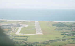
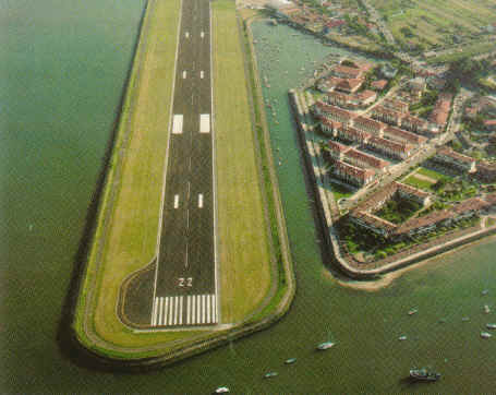
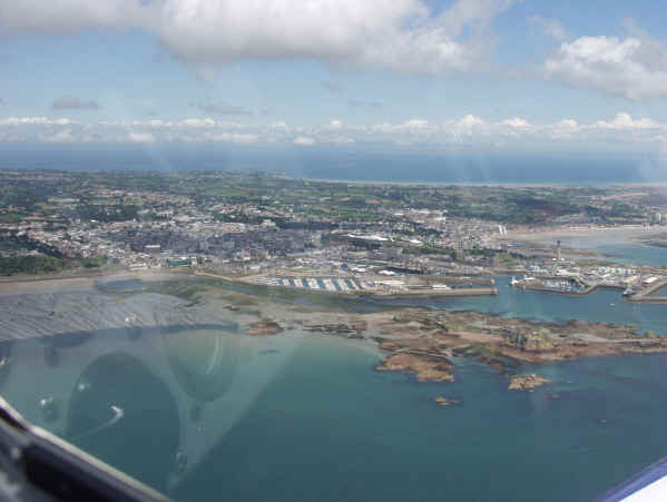
above:
our route goes over four maps. above far left: Jersey airport.
left Jersey island.
We have a quick drink and head-off, but we hit another delay. Jersey is a very busy airport and we are held in a queue at the hold for 25 mins. Eventually we are cleared and depart Jersey heading for Dinard (LFRD) at 13:50. Once clear of Jersey zone I climb to 3,500ft and contact Dinard TMA. They clear me direct over head and track to St Nazaire (LFRZ). There is not much to say about this part of the route, other than Jo fell asleep! This was going to be my longest leg and I had thoroughly planned all the reporting points and frequencies I would possibly need. We plodded through France, Dinard to St Nazaire not seeing another aircraft. From St Nazaire the rest of the route took us along the French coast, so the navigation was not difficult. The coast line had some good visual references to keep track of. Some challenges were the reporting points I was requested for.... with both me and Jo looking for the places on our maps. We carried the French 'Carte Aéronautique OACI' maps and the Jepperson - Jepperson usually have the places they requested shown as a VRP. I called La Rochelle, armed with the chart I know where the airfield is - well should be - but can't see it. When asked to report when visual I am honest and say I can't see it! "Can you see the bridge", I can and follow the visual clue to the airfield. The airfield chart show the local circuit route and I join downwind for runway, landing at 16:30 local. We quickly refuel and file a flight plan via telephone (to Bourdeaux) in the tower for our next leg. A Ryanair flight arrives and departs while we fuel and have a late lunch. To gain access to the terminal and return to the aircraft I am required to show my pilots license and some form of photo ID (eg passport). |
||||||||||||||||||||||||||||||
|
Returning to the aircraft we somehow get mixed in with the Ryanair passengers, as I didn't (at the time) realise we should have exited where we came in!! Obviously when we got to the gate we didn't have a boarding pass. I showed my pilots license and explained I was a Pilot - Jo was amused by the look of some of the passengers we stood amongst - and we were allowed through! We depart La Rochelle at 17:47(local) climbing out over Pertuis d'Antioche, heading south there is quite a number of airfields close together - some with parachute dropping activities - navigation around them is helped a great deal by the coastal features. A direct track to Vendays (LFIV), takes us over some beautiful scenery and I kept clear of the drop zones. I established initial contact with La Rochelle Info and as I depart the area I switch to Aquitaine Info. This is necessary as the whole area has airspace restrictions, I settled at 4000ft as this would take me above and below most of the areas. Soulac-sur-Mer has paradropping and is close to Vendays but again the good costal features ensure I don't mix them up! Just past Vendays are some airspace restrictions, again the coastline and lake's help us keep to track and Jo is really getting into the navigation - she's enjoying keeping track of our route. Once past Bordeaux I switched to Biarritz Info and transited Biarritz. This is where the pace picked up, as soon as I left their zone I quickly contacted San Sabastian approach and started my decent to the airfield. The San Sabastian plate makes the airfield sound great, 1,700m of asphelt just 130ft above sea level. Read it closely and you will see it is surrounded by 6,000ft safety sector! I called up and was given the wind, then runway at your discretion - not an unusual comment - but it did throw me at first as I expected to be told the runway to use at this size of airfield, I quickly decided which runway direction would be best. I joined down wind for 04 which was daunting being below the mountains. As we turned base Jo commented "Oh the runway is in the water, don't miss it or we will be in the drink...." Thank you!! After landing a follow me car arrives and we taxi to an empty apron, we grab our bags and head into an empty terminal. We go to Control and book-in, they are really friendly and help find a hotel - it's a busy time but they find a room and call a taxi for us. |
|
||||||||||||||||||||||||||||||
|
|
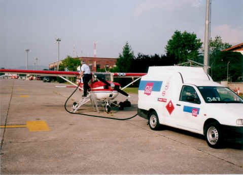
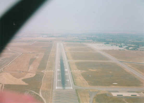
above:
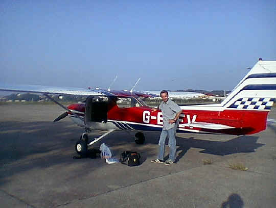
Just landed San Sabastian, we have got to Spain! left: San Sabastian
airfield - easy - just avoid 7,000ft mountains around it! below:
Re-fueling EV at San Sabastian (out the back of a van?), not very busy on
Sunday morning.
|
||||||||||||||||||||||||||||||
|
Our return to the airport the next morning does not go as well as we would have liked. There had been a car accident right outside the airport and the emergency services were doing their best to save one persons life - there was one fatality (our taxi driver told us) - a start to the day like that doesn't bode well. San Sabastian has an excellent met service and I check out the weather and file for our next destination Zaragoza (LEZG). In Spain all flight's require a flight plan, so I filed and got the weather while Jo loads EV with our luggage I checked out EV thoroughly, we are now along way from home and will be flying over some remote areas. We called for startup and taxied for 22, as this was not out to sea I ensured I went all the way to the start of the runway!! We took-off at 11.00 local. The controller cleared me to depart direct to Pamplona, but I requested to continue my climb in the overhead which he granted. There was a little cloud around and I wanted to ensure I had my height before I headed away and keep well clear of the cloud - Flying in the Fens, clouds may have another aircraft in them, here they could have hard centres.... mountains - so I wasn't taking any chances and gained plenty of height. We departed San Sabastian on a direct heading for Pamplona, as we flew along I couldn't help but notice there was not many places to attempt a forced landing if needed, this was very mountainous. There are not many airfields in Spain and this was my biggest consideration when choosing the route, not just planning for fuel, it was a challenge planning possible diversion airfields. With this in mind I decided to route over Pamplona. We called Pamplona and were cleared en-route direct to Zaragoza. As we left the Pamplona area we left the mountains behind but this is where it was became barren, nothing at all, as we looked out there was hardly a road, or house in sight! Around this time Jo commented she was pleased I had included an ELT with our kit, "they would never find us down there" Gradually Zaragoza came into view. Zaragoza is a combined Millitary and Civil airport, it has two 3000meter runways next to each other (other runway can just been seen on left in picture below). I called up and was asked to report at "November". Jo described how she imagined what Las Vegas must be like in the middle of the Navada desert, looking down at Zaragoza. There wasn't any other traffic to worry about, just very slow progress against a 20 knot wind on final to 30R! Oh and an Arresting Cable.... A follow me car came out and directed us to our parking, we then headed off to pay our landing fee of €4.04. I immediately filled a flight plan and arranged for fuel, we had a quick drink and the fuel truck arrived and we fueled quickly. We did however have to pay in cash, but this may have been due to the small amount of fuel I was loading. This was just a short hop (1.5 hrs) from San Sabastian, with so few airfields to divert to, the higher altitudes, power settings and heat I decided I didn't want to push my fuel range.
|
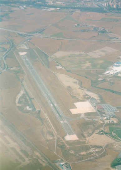
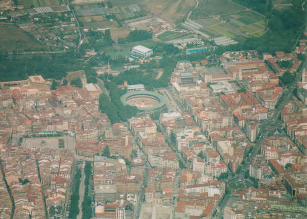
above: Pamplona airfield, below: Central Pamplona - showing the bull ring!! |
||||||||||||||||||||||||||||||
|
|
||||||||||||||||||||||||||||||
|
We departed on the same runway and were instructed to turn left, as I did I could see why. A fighter jet was lined up on the runway behind ... and started his run as soon as I departed the runway line. Again the landscape became very baron, I was on a heading for Caspe. I did this to bring my track East before heading south as this would keep me clear of some high mountains. Once at Caspe I took up my track to Tirig, again to keep away from the high mountains. As we approached Tirig we were again in mountainous area, I had already climbed to 7000ft, next heading was Valencia. The coast started to come into view and I called Valencia - now here there was a lot of traffic, small GA coming in my direction and another airfield (LECN - Castellon de Plana) to my left with paradropping. Valencia APP instructed me to report at "November" (EL Puerto de Sagunto) at 2'500ft, as we descended the temperature started to raise. At "N" we were instructed to report at "Echo 1" at 1'000ft. Now the temperature was high. Approach instructed me to "join downwind next to the tower", I did and was instructed to call the TWR, they fitted us neatly with the "big stuff" and we landed on 12. We were jumping for joy, we had done it.... Flown all the way from Popham to Valencia... Spain! In Evy our little Cessna 150! | ||||||||||||||||||||||||||||||
|
|||||||||||||||||||||||||||||||
|
The Return.... As I have described the outward journey in great detail the return trips brief! Departing Valencia was delayed due to a large queue at the fuel pump, but we did eventually depart more than 1 hour late. Again we stopped at Zaragoza, this turn around was quick as we knew where to go etc. Next stop was Biarritz where we stopped for the night. We booked into a hotel by the airport as we wanted a quick getaway in the morning. Biarritz is a nice town and we enjoyed our dinner and celebrated our flying trip in town. Departure from Biarritz was good next stop was La Rochelle. Landing at 12.01 where we were told the fuel was shut until 2pm! After finally getting fuel we departed LaRochelle for Jersey. We were going to stop in Jersey for a while but after the delay at LaRochelle we decided to continue - we managed a turn around of wheels down to wheels up in one hour five mins! Last leg, via the French coast to IOW. I called Southampton and they allowed me to enter their zone direct to Popham. I was pleased with my dog-leg landing on Pophams 26 runway, to see my old CFI from Sibson standing watching me!!! |
Useful
Links.....
The Spanish AIP Here are all the airfield charts and data you need for flying in Spain. And IT'S FREE!!!
|
||||||||||||||||||||||||||||||
| Copyright © 2007 GA Pilot .co.uk All rights reserved. All pictures are property of GA Pilot (unless noted) please do not reproduce. The contents of this site are the opinion of the author not the LAA, FAA or CAA. Please check all information is correct before you act upon it. | |||||||||||||||||||||||||||||||